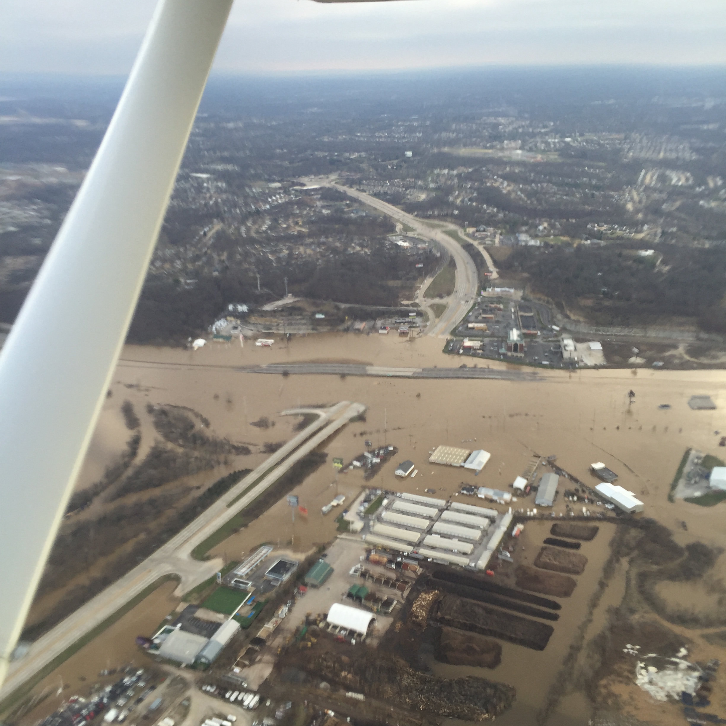
Photo of flooding at 141 at I-44, courtesy of the Missouri Department of Transportation.
The December 2015 record-breaking flooding was the topic discussed by Lower Meramec River government agencies and other interested parties at a public meeting held recently.
One issue highlighted was the new high water marks established at Pacific, Eureka, and Valley Park.
Meeting Coverage By Jo Schaper
On February 26, 2016, Lower Meramec River government agencies, environmental groups and interested citizens came together at the McHugh Daily Opera House, a historic building in downtown Pacific, where just two months before, over 40 inches of water stood in the lower level of the building, built partially of construction materials recycled from the 1904 World’s Fair.
The attendees were there to recap, discuss and debate the recent record-breaking flood, and to plan for the future, knowing full well that someday the river will rise again. The best time to plan for that eventuality is now.
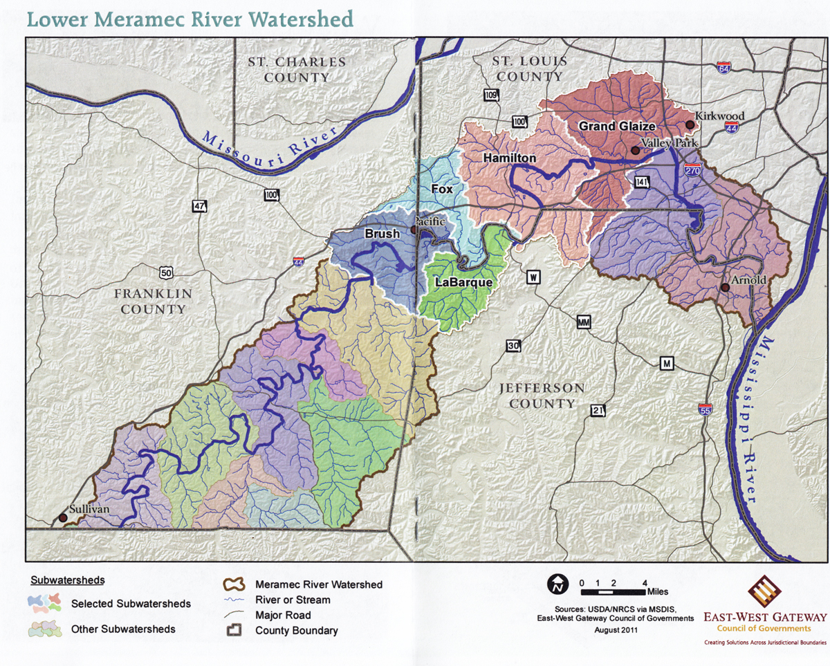
Map courtesy of East-West Gateway Council.
Officials from the Army Corps of Engineers, the U.S. Geological Survey, Missouri Departments of Natural Resources, and Transportation; Franklin, Jefferson and St. Louis counties; the cities of Arnold, Fenton, Valley Park, Eureka and Pacific; the East-West Gateway Council of Governments; the Open Space Council, The Nature Conservancy, the Meramec River Tributary Alliance and Meramec River Recreation Association took the microphone in turn over the five and a half hour meeting to recap and discuss the basin-wide flood on the Meramec River, at its peak from December 27, 2015, to January 4, 2016.
Seventy-six people attended the event, including representatives from other non-governmental and environmental groups, and interested citizens. The agenda and copies of the presentations from the meeting are online HERE, courtesy of David Wilson from East-West Gateway.
The morning session consisted of introductions and recap of ongoing natural resource assessment and environmental planning efforts along the Lower Meramec River, which is defined as from Sullivan to the confluence at Arnold. Highlights of the morning were a report from Our Missouri Waters, an MDNR statewide assessment of 66 Missouri watersheds. The lower Meramec is of special interest because it is considered an impaired watershed mostly due to urbanization and human neglect.
Copies of the Lower Meramec Watershed Plan (Pacific to Valley Park) were passed out – a study funded by EPA Region 7 to assess the health of the system in detail. Of special concern, even before the flood, is the condition of the Big River from Morse Mill to its confluence with the Meramec at Twin Rivers due to the lead, barite and clay contaminated sediment load, and four low head mill dams on the river which interfere with sediment transport and fish migration. Options being looked at include removal of the historic dams, or fish passages around them, but no decisions are imminent.
Remediation of this ecological area has already been authorized and tasked to the Army Corps of Engineers as part of the Meramec River Feasibility Study. Despite its title, this study, which runs through 2018, is designed to “protect, enhance, and restore degraded aquatic habitat in St. Louis and Jefferson County” along the river, concurrently with that area becoming more thickly settled. Bank stability, erosion prevention, and a federally endangered mussel study are part of this effort. Final recommendations will not be sent to Washington D.C., until August of 2018.
John Peukert of the Army Corps of Engineers spoke of the Corps involvement in removing hazardous flood debris, in concert with the EPA, and the effects of the Valley Park levee in protecting that city, saying that only minor alterations in stage height or water velocity were felt up and down river from that structure. He emphasized that the ecological study was the only Corps project authorized at this time and that the agency, like most, was under financial sequestration constraining their activities to only those authorized by Congress.
After lunch came the real focus on flooding and its effects. New high water marks were established at Pacific, Eureka, and Valley Park. Amy Bussink and Paul Rydlund of the USGS Water Resources office in Rolla first explained the usual behavior of USGS field crews capturing stage height, water velocity and flood volume, and how it provides a data input stream to the National Weather Service, which in conjunction with their rainfall data, predicts the stage height for the river at measured locations. More information can be found HERE.
Especially interesting is a USGS service coming online across the country called Flood Inundation Maps. Using data collected from the previous flood, plus stage hydrograph data from the National Weather Service and very precise topographic/elevation maps, the program is able to generate flood maps, showing which streets and buildings are likely to be affected in near real time.
Rydlund showed how the system works on the Blue River in Kansas City, and said a similar system was possible to build, with the aid of local partnerships, on the lower Meramec. Like many federal efforts, a local cost share is required for implementation. Further information can be found HERE.
The afternoon consisted of three panels: the first, a cities panel, with representatives discussing the impact of the flood on their respective towns; a utilities panel where people men from Missouri American Water and the Metropolitan Sewer District discussed flooding impacts and recovery, with Jay Hoskins of MSD announcing that the Fenton Treatment Plant had resumed primary treatment, with the plant to be fully back online sometime in April, and a transportation panel, with Karen Yeomans of MODoT discussing the temporary but unprecedented loss of both I-44 and I-55 at the height of the flood, and possible prevention of this in the future, while Bernie Arnold did the same for Jefferson and Ron Williams for Franklin county roads.
People seemed pleased with the information and contacts exchanged at the meeting. The group seemed interested in working on watershed issues going forward but no new large group actions were planned or proposed that day.

Stream Team Clean Up. Photo courtesy Jay Doty.

OK, Jo, here is the question that I have for this meeting. Aren’t there some wetlands areas that could be opened upstream and flooded in these super storms to provide some relief for Eureka, Pacific, Fenton, Sunset Hills and Arnold? Surely, flooding some lowlands would be a lot less costly then cleaning up commercial areas when I-44 and Hwy 141 go under water. Looks like there are plenty of lowlands in your topographical map here of the Mermen Valley.
LikeLike
Hi Don,
I had a technical issue to work out before I could respond.
I’m not sure what wetlands you are referring to. (See large scale map http://geocommunications.net/wp-content/uploads/2016/03/bourbeusemeramec.jpg ). Both the Meramec and Bourbeuse rivers are highly incised streams. That is: the rivers have cut down into their valleys to the point that they are trapped there. I do not see any wetlands from Sullivan downstream on the Meramec, nor on the reaches of the Bourbeuse. The river is pretty well cut down into its channel. You can tell this by the snaky, sinuous paths the river takes. It does not spread out across a wide valley like the Mississippi and Missouri do at the Missouri Point — West Alton, Mo. There are streamside fields in some places: but these are only not actual wetlands; they are high enough they are dry most months of the year. Most of these fields are behind high banks on both sides; the few places like the bottomland forests of Shaw Nature Reserve and Glencoe are not very wide, and are accompanied by high bluffs. While it may seem “logical” to flood someplace like the streamside bottomland adjacent to Bend Bridge, the owner of the property is actively farming the fields; it would take big money for a buyout or a floodway agreement; and those areas already do act as backwaters detention for areas downstream.
Secondly: (See second map at http://geocommunications.net/wp-content/uploads/2016/03/Pacificarea.jpg ) the apparent ‘wetlands’ on this map are not wetlands at all, but old sand and gravel pits. Those south of Pacific are the Catawissa Conservation Area; a nice place to fish, with a couple of geocaches and at least one old abandoned sand barge. This is also the case in Eureka at the 109/FF/W intersection: the top couple of feet is dirt, but below that, it is all sand and gravel. There is an sand excavation operation on the southwest side, on the southeast side is a fill site. From at least 1962 to about 5 years ago, this area was bottomland farmed; now it is designated to become a shopping center by the people who erroneously believe you can build your way out of a floodplain. The entire site was underwater last December; it is another Union, Missouri Old Wal-Mart/now Dickey Bub in the making. (A shopping site next to a river which is guaranteed to keep flooding, even on a 5 to 10 year frequency.)
These sand and gravel areas are amongst the first to fill from the groundwater up; they are also the first to drain, (unlike dirt, soil, loam or clay). The entire Meramec Valley until you get far enough upstream to have bedrock riverbeds is like that: a lot of sand and gravel is glacial outwash, and works excellently for construction materials, but it makes a lousy sponge.
The Big River in Jefferson County is also fairly incised, (think Twin Rivers Road and Highway W from Eureka to Cedar Hill) though it does have wider river valleys; at the same time, those valleys are more populated and suburban and therefore more likely to have to remove people in order to preserve any flood retention. Plus, the Big River, as the stream draining the Old Lead Belt and the barite strip pits of Potosi has a whole nother can of worms to deal with.
All of this is old news: the nature of the valley bottom materials is part of the reason that at its greatest extent the Meramec Basin project had the obscene number of 31 dams on the Meramec and its tributaries, and part of the reason the engineering was sketchy enough that they were not built.
Jo Schaper
LikeLike
Thanks, Jo,
Although, your answer has to be disappointing to people who live in the Mermen River Valley in the St. Louis area. Your answer is that there is no real relief area for the water to settle in upstream. It is all going to head to Pacific, Eureka, Valley Park, Fenton and Arnold and flood those areas, before finding the Mississippi River.
I should post my story last week in the SCT with Jim Kramper of the Weather Service, who warned that more flooding rains like the December 2015 storm are in our future. My SCT story has plenty of photos on the South County Times website of the damage that still has to be cleaned up from the 2015 storm — amazing damage!
LikeLike