

Bottomland trees (e.g. Sycamore, Elm) in Greentree Park, near proposed bridge. GRG describes trail (far-right) as; “Travels through the riparian forest along the Meramec River. This wooded area helps to control sediment in water, reduce damaging effects of flood and prevents riverbank erosion and provides food, shelter and water for diverse wildlife.” Why build here?
By Don Corrigan
A proposal to link Kirkwood’s Greentree Park and St. Louis County’s Unger Park is in its exploratory phase – with a formal public campaign set for this fall. However, the idea already is facing opposition.
Great Rivers Greenway (GRG) is conducting a feasibility study for a pedestrian and bicycle bridge that would connect the two parks. It also would tie together a trail network that runs along either side of the Meramec River.
“Rivers are a barrier, obviously, so this is an opportunity for people to connect across a major waterway,” said Great Rivers Greenway’s Emma Klues.
“In our studies and our surveys, people tell us they want us to work on these kinds of opportunities,” said Klues, vice president of communications and outreach for GRG. “They want these connections.”
Great Rivers Greenway representatives have been in communication with affected communities in the trail areas within their borders. According to Kirkwood Parks and Recreation Director Kyle Henke, the city has been contacted as Greentree Park is a Kirkwood Park.
The possibility of such a Meramec River Bridge was first evaluated during a flood study of Unger Park, which itself is now being redeveloped by GRG in partnership with St. Louis County.
Opponents Decry Plan
Among those opposing the GRG bridge plan are environmentalists like Linda Fenton of Kirkwood and Scott George of Jefferson County. George and Fenton note that the increasingly violent floods in the area are problematic.
Higher flood waters in the Meramec, and torrents that rip away the shore land, make a new bridge dicey – and costly, according to these area residents. There is no shortage of evidence of river bank erosion.
“The Meramec River requires ever wider channels and riparian zones to handle the ever-increasing frequency and magnitude of floods,” said George. “These are being caused by urban land use and climate changes.

Greentree Park pavilion destroyed by spring 2025 floods.
“Any structure built to withstand these mega-floods will need to be massive and expensive, with piers to bedrock, large riprap, diversion structures and more,” said George. “ADA compliance will require low-slope ramps on both sides of river, and they also will require protection.”
Fenton of Kirkwood also mentioned the flooding issue. Damage to structures at Greentree, Emmenegger, and Minnie Ha Ha parks along the Meramec River this past fall and spring has alarmed park officials at those sites.

Flooding is a common occurrence at proposed bridge locations (2016 Google Earth).
“GRG’s current plan for the bridge requires a huge elevation to minimize conflict with the natural seasonal river flooding carrying storm water from Central Missouri,” said Fenton. “That flooding often reaches 20 to 30 feet higher than the normal level of the river.
“To achieve ADA compliance, extensive switchbacks would have to be constructed,” added Fenton. “All of this would take up about one-fourth of our riverfront (Greentree) park – right through and next to a pastoral riparian forest and vital wildlife corridor.”
Both George and Fenton also noted adverse impacts to wildlife with the bridge, switchbacks and trail additions.
“Proposed development is within the Meramec River wildlife corridor, which is under increasing stress from urbanization,” said George. “Allowing for wildlife movement is considered vital for maintaining biodiversity.
“The nearby Emmenegger Nature Park is a biodiversity hot-spot, which requires connection to other nature areas for survival,” he said. “Another barrier to wildlife movement with this new construction will not help.”
Kirkwood Fields Questions
Kirkwood Parks and Recreation Director Henke said his office has been fielding questions about the proposed bridge. He emphasized that the city has no formal role in the planning or a position on the project at this time.
“It is very important to note that this is an early-stage feasibility and conceptual planning effort with no formal proposal or funding commitments at this time,” Henke informed the Kirkwood mayor and city council members on June 3.
“The primary goal is to engage community members in both Kirkwood and Fenton to gather input on the bridge’s feasibility, location and conceptual design,” Henke added.

Eroded bank and parking lot from spring 2025 floods. Greentree Park.
Kirkwood’s Greentree Park has been the object of ongoing discussions as the city revises its decades-old parks’ master plan. A red line representing the proposed GRG bridge was included on a sign board of Greentree Park presented for community feedback in May.
Like Unger Park, Greentree Park is frequently flooded, and park structures were damaged and destroyed by the rising river this past fall and spring.
GRG leadership needs to give approval for the bridge project to move forward, but the organization likely will “get the ball rolling” this fall, according to Klues. She said GRG is now in the community engagement phase to get feedback.
A year ago, Great Rivers Greenway celebrated the completion of a pedestrian and bicycle link crossing incorporated with the redesign of the Interstate 44 bridge over the Meramec River. That GRG bridge link has been criticized as “the bridge to nowhere,” as it doesn’t link to any trail in Kirkwood.
The Missouri Department of Transportation led the effort with the cities of Kirkwood, Fenton and Sunset Hills all partnering for that project. The pathway on the I-44 bridge provides a connection to Unger Park from a new trailhead at Stoneywood Drive on the east side of the river.
Critics point out that there is no continuing bike or hiking trail on the Stoneywood Drive side. However, a new trail on the east side from the I-44 bridge could link to both Grant’s Trail and to Greentree Park, and would likely be much cheaper than building a bridge over the Meramec River.
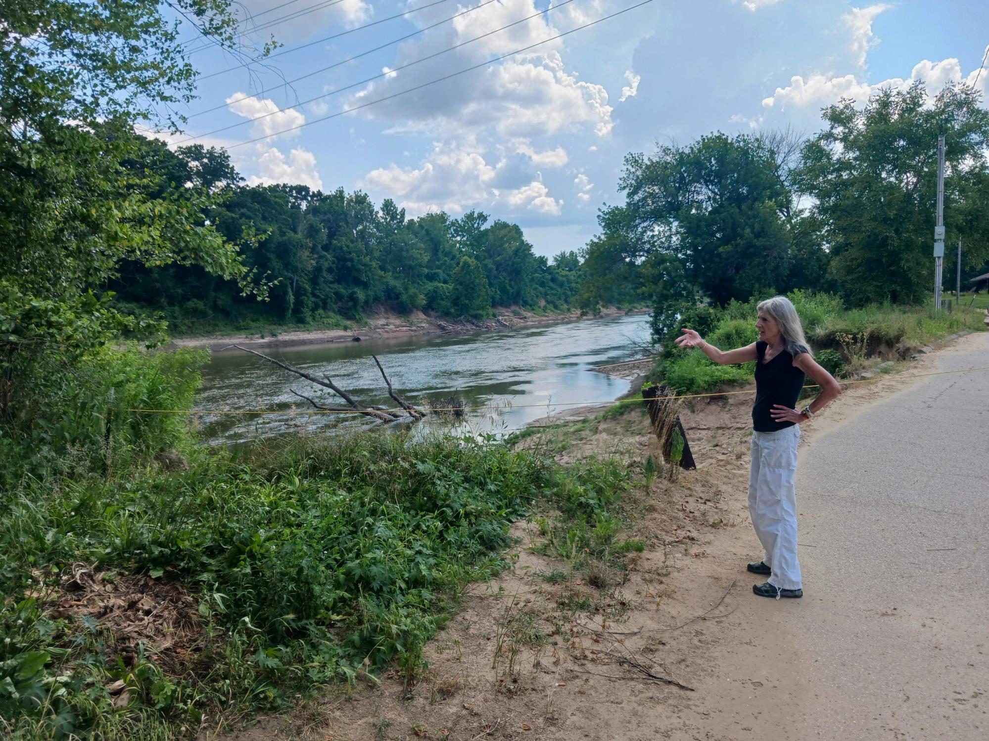
Concerned citizen, asking why bank stabilization/restoration are not the priority.

Proposed bridge alternatives with mapped Regulatory Floodway (red-stripes), 100-year floodplain (dark-blue) and 500-year floodplain (light-blue). The system is already under stress due to watershed urbanization and climate change.
